
Our planet is very vast. There are endless miles of roads, paths, and trails that would be almost impossible to count on this planet. The cartographic work to gather this information is unimaginable. The list of places that we do not know is endless. Because of this collective need, Google Street View was born. Google Street View is a Google function that shows a 360° view of the streets registered by this company. But nothing is static, and everything changes, and cities and streets are no exception. Because of this, the question may arise: how often does Google update Street View photos?
There is no formal schedule that establishes the update frequency of Google Street View. If you live in a busy residential area, Google might update the images every two or three years. On the other hand, if your residence is in a rural area, this update may take several years.
Google Street View is an increasingly important feature alongside Google Earth and Google Maps. Searching for certain places can be a complex task even when using this tool. For this reason, many people combine it with Google Maps to facilitate the location of places.
Despite all this technology, there is still a long way to go. There are still many places to be captured and incorporated into the platform. It is also likely that areas that are on Google Street View will need updated imagery. If you are curious to know much more about Google Street View, features, and update frequency, continue reading this article.
Understanding What Google Street View Is
Google Street View is a versatile feature of Google Maps and Google Earth that allows us to view panoramic images at street level. The wonder is that you can give each image 360° of horizontal movement and 290° of vertical movement. This facility allows people to see the streets of the chosen cities along with the surrounding areas.
The first appearance of Google Street View occurred on May 25, 2007. Google launched this functionality in five U.S. cities. Today Google Street View is present in many more continents and countries:
- Europe: 31 countries
- Asia: 17 countries
- Latin America: 10 countries
- Africa: 5 countries
- Antarctica
Google Street View is a very easy-to-use tool. You can easily navigate through each image using the keyboard or the mouse. At the moment of taking the photos, Google considers the weather, time, and temperature. Another critical point to know is that Google distorts the images of people’s faces and vehicle license plates to protect privacy. Google also lets you request to blur your entire house, car, or body.
Some Historical Data On The Evolution Of Google Street View
Here are some historical events that reflect the development of the Google Street View platform over the years.
- December 2007. In the early days, Google relied on other providers for images, but things changed in 2007. From that moment on, Google Street View uses images that are exclusive to Google.
- June 2008. At this time begins the distortion of faces and license plates as a privacy protection measure.
- November 2008. Google removes the Street View button and the camera icon from Google Maps. Here the yellow doll (Pegman) is introduced, a kind of cursor that we will place on the map to indicate the area we want to observe.
- February 2010. Google launched Street View in Canada in conjunction with the Winter Olympics. The platform allowed people to observe the snow slopes and different landscapes of this sporting event.
How Often Does Google Street View Make Updates?
We said at the beginning that there is no concrete answer on the subject of updates. What we do know is the following:
- There is no specific frequency for making Street View updates.
- Google prioritizes residential areas over urban areas.
- Google prioritize places where it is not yet present over updates to areas where it is already present.
With all these facts that we have just learned, we can understand that Google still has a lot of work to do. Regarding the timing of updates, we must understand some aspects. Indeed Google does have a calendar and specific goals to make image updates. However, this information is not public.
You also have to consider that the work does not end when Google takes each image. Let’s remember that Google has to prepare each picture in detail before posting it on the web. This preparation consists of the work of pixelating people’s faces and car license plates. One way to check the age of the image is to check the image capture box, where the month and year of the selected image should appear.
How Does Google Get The Images For Street View?
Google has several methods for obtaining Street View images.
Recording Cameras
This method is a system of eight high-resolution cameras that Google temporarily installs in different areas or locations to take the images that will feed its platform. This system also consists of powerful scanners that record 3D information of the site that Google needs to photograph.
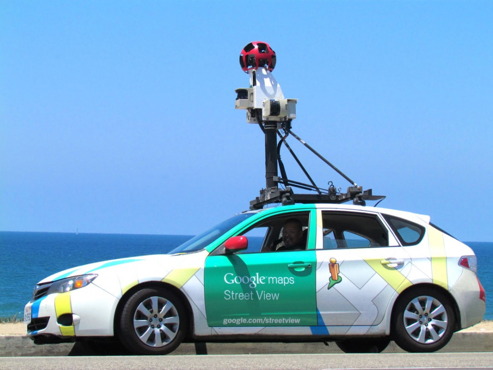
The Recording Car
This method consists of a car that drives through the streets of a selected area. The car has a data recording system on its roof. In some cases, the vehicle is replaced by a recording tricycle if the street is tiny. Google also uses recording boats to take images from canals. Google even hires ordinary people to attach cameras to their backpacks and record every street they encounter while walking.
The Advantages Of Google Street View In The Business World
Don’t think that Google Street View is only for locating addresses. Google Street View also has an exciting field of action in the business world. Let’s take a look at some of its advantages.
Google Street View Helps Build Trust With Customers
The best way to build trust with customers is to humanize the business. An effective way to humanize the business is to include a street view on your web page. We will achieve this thanks to Google Maps and Google Street View. This possibility for your customer to get to know you better stimulates a space of comfort and trust. You are showing what you do, not just telling.
Google Street View Helps In The Research Process
According to Forbes magazine, 82% of people research online before making a purchase. The ability to see the street of your company or business through Google Street View is part of that research process. This platform will allow your current and potential customers to make a virtual visit to your business. This first contact between you and the customer will be critical. The first image they take with them will be fundamental for the negotiations they hope to make.
It’s An Opportunity To Demonstrate Quality Using Google Street View
Google Street View is not only helping the customer research process. It is also essential to support and verify the quality of your business, product, or service. It is a wonderful way to convey the message that “there is nothing to hide.” With one click, your customer can enter your business.
Google Street View Helps You Create A Better Connection With The Customer
When you use this platform, customers know that you are honest, that you exist. Google Street View allows the customer to let their guard down a little bit.
We Will Be Able To Have Better Access To The Target Audience
You will be able to show your target customers that you have something unique and different to offer. For this reason, we must understand that Google Street View is the first showcase you will have to showcase the best of your business.
You Help Your Customers Make Better Thought-out Decisions
Some details may go unnoticed at first glance. Such as whether the area where your business is has places to park the car. Using Google Street View, you will give your customer all the relevant information they need to help their decision-making.
Google Street View Helps Us To Create Passive Marketing Strategies
All your customers will become word-of-mouth marketing agents, thanks to all the experience you provided them. Being on Google Street View will make it very easy for a satisfied customer to share some of this experience with others.
Using Google Street View Is Convenient And Very Practical
All people can make inquiries about your business from wherever they are. Additionally, this is a year-round platform; it is available 365 days per year.
A Final Thought About Google Street View Update Frequency
It is not realistic to think at the moment that we will have periodic updates on our streets. Google Street View gives more priority in some instances to new places than to update the sites they already have.
But we should not worry too much, as Google is aware of the growth of this platform. So we can be confident that every day these update processes are being perfected. We cannot forget that the work of registering images all over the planet is quite a laborious process. However, the world is rapidly moving towards this type of technology, which guarantees that Google Street View will continue to improve in the short term.
Related Posts:


on street view, there is still a car in my driveway that I have not had for 11 years
So I understand that there cannot be a fixed schedule, and there are a lot of variables. But I would like to see some transparency, like where is the update in progress, where is it scheduled, what is an ETA of an update. Same for satellite imagery.
Good points. It would be nice if someone from Google could answer.
I have just seen the Google street view car passing my house .How long before I can see this up date?
Well, it’s not as immediate as you might think. Generally, it can take anywhere from a few months up to a year. Why, you ask? Well, after taking those cool images, they need to be polished. That involves a bit of stitching and blurring. This makes sure privacy is respected when the images go live online. So, my advice? Keep an eye on Google Maps. Check it out every so often over the coming months. You’ll get to see the new images as they get added. But remember, there’s a bit of unpredictability here. Not all captured images make it to the final cut. So, patience is key.